
Table of Contents
- How Often Do Wildfires Occur in the US?
- Where Do Wildfires Occur Most Often in the US?
- How Often Do Wildfires Occur in California?
- How Often Do Wildfires Occur Around the World?
- How to Check Wildfire Frequency Where You Live
- What Wildfire Frequency Should Change About How You Prepare
- Where the FORT Fits in a Layered Wildfire Plan
- Frequently Asked Questions
- Key Takeaways
If wildfire has never reached your neighborhood, it can be easy to think of it as a problem that happens somewhere else. You see the maps and the evacuation footage every summer, but the fire is always somewhere else, some other county, some other family.
So how often do wildfires actually occur, and how often do they happen near you? The national numbers are large, tens of thousands of fires a year across millions of acres, but those fires don't land evenly. Some states experience far more wildfires than others, while different states account for the most acres burned. Wildfire activity also peaks during certain times of year.
This guide walks through how many wildfires the country sees in a typical year, which states and regions burn most, how California's season and winds drive its numbers, and how the US fits into the global picture. It ends with the free tools that show your own area's wildfire likelihood, and what that number should change about how you prepare. Evacuation always comes first in any fire plan. Knowing your real frequency is how you decide how hard to plan around it.
In Short
The US averages about 63,000 wildfires a year, burning roughly 7 million acres, but the risk concentrates in specific states, seasons and weeks. The number of fires each year has stayed fairly steady over the past decade while the acreage burned has climbed, so the trend is toward larger fires more than more frequent ones. What matters for your household isn't the national count. It's how often fire is likely where you live.
Wildfire frequency should determine how often you review and update your preparation plan. Even areas with lower wildfire frequency can experience destructive fires. Evacuating early on the first warning is always the safest choice. For the case where evacuation is cut off, an on-site refuge like the FORT® is one layer of a broader plan that still puts leaving early first.
How Often Do Wildfires Occur in the US?
The US averages about 63,405 wildfires a year, burning around 7.1 million acres, based on the 2016 to 2025 average tracked by the National Interagency Fire Center. That works out to more than 170 fires a day, though the great majority are small and put out fast. The ones that make the news are the exceptions, not the norm.
The long view. Recent years show how much a single season can swing. 2024 ran high, with 64,897 fires and about 8.9 million acres burned. 2025 came in well below that, around 5.1 million acres, a 43% drop from the year before. Looking across several decades gives a clearer picture. Since 1983, the country has recorded roughly 3 million wildfires that burned nearly 230 million acres combined. The count of fires per year has been relatively flat across those decades. The acreage has trended up. Wildfire frequency has remained relatively steady, while the number of acres burned has increased.
When they happen. Most US wildfire activity falls in summer, driven by the West's dry months of July and August. The Southeast and Southern Plains run a different calendar, with a spring peak. Across the West, the season keeps stretching earlier and later, closing in on year-round in the driest regions.
How they start, and when people start them. About 85% of US wildfires are human-caused, from equipment sparks and escaped debris burns to vehicles, power lines and fireworks. Human-caused ignitions increase on weekends and around holidays. One analysis found nearly twice as many wildfires recorded on the Fourth of July as on an average day in the West. Lightning starts the rest, and those fires often burn in remote country, which is part of why they account for an outsized share of total acreage.
Where Do Wildfires Occur Most Often in the US?
Wildfires occur in every state, but some states experience far more fires than others. The states with the most wildfires are not always the states with the most acres burned.
| Rank | Most wildfires (2024) | Most acres burned (2024) |
|---|---|---|
| 1 | California: 8,316 | Oregon: 1,797,796 |
| 2 | Texas: 4,967 | Texas: 1,314,903 |
| 3 | North Carolina: 4,668 | California: 1,081,144 |
| 4 | Oklahoma: 3,041 | Idaho: 996,762 |
| 5 | Missouri: 2,804 | Alaska: 667,075 |
Fire count and acreage burned reflect different wildfire patterns. Fire count tracks people, because people start most fires, so populous, fire-prone states like California and Texas and heavily wooded ones like North Carolina rack up high numbers of ignitions. Acreage tracks fuel, terrain and remoteness, which is why sparsely populated interior-West states and Alaska dominate the burned-land column. Alaska alone topped a million acres in 2025.
A high state fire count doesn't automatically mean high risk at your address, and a low count doesn't mean you're safe. State totals are too blunt to plan a household around. You want your local number, and there are tools for that further down.
How Often Do Wildfires Occur in California?
California usually leads the nation in the sheer number of wildfires, running into the thousands every year. In 2021, for scale, the state recorded 8,835 fires that burned about 2.57 million acres. California’s wildfire frequency is driven by three major factors: human ignitions, long dry summers and strong winds.
The season, north and south. Northern California's fire season generally runs from June or July into late October or November. Southern California starts earlier, from late spring, and can run through October. Climate trends keep pushing both ends of that window wider.
Why fall winds increase wildfire danger. The most destructive California fires often come in the fall, even though fewer fires start then. That's the work of the offshore winds: Santa Ana winds in Southern California and Diablo winds in the north. These are hot, dry winds that can gust to highway speeds and push a fresh ignition into a major fire within hours, faster than crews or residents can react. September and October produce fewer starts but far bigger consequences. If you're in California, those are the weeks to have your plan already running, not still on the to-do list. For the wider picture, see our guide to fires in California and what the state is doing to reduce them.
How Often Do Wildfires Occur Around the World?
Globally, wildfire burns a staggering amount of land each year, which puts the US share in perspective. Between March 2024 and February 2025, fires burned roughly 3.7 million square kilometers worldwide, about 370 million hectares, an area larger than India. The US, for all its bad seasons, is a small slice of that total.
Most of the world's burned area isn't forest. Tropical and subtropical grasslands and savanna, much of it in Africa, account for around 70% of global burned land, where fire is a regular part of the ecological cycle. And that 2024 to 2025 figure came in about 10% below the two-decade average, so global burned area isn't simply climbing every year, even as individual fire seasons grow more severe in forested, carbon-rich regions.
Global wildfire totals are driven largely by grassland and savanna fires, so they do not reflect the wildfire frequency around a specific US home. Your national and local numbers are the ones that should drive your planning.
How to Check Wildfire Frequency Where You Live
Two free tools can help you understand wildfire likelihood in your area, and neither requires an account. No free tool returns a literal fire-count-per-year for a single address, so it helps to know what each one actually gives you.
Wildfire Risk to Communities (national). Type your state, county, community or tribal area into the USDA Wildfire Risk to Communities tool and its Wildfire Likelihood reading shows the probability of wildfire burning there in any given year, rated Low to Very High and compared against other US counties. There's no address or zip box, so treat it as the view over your county rather than your parcel. It's the closest thing to a plain "how often" answer for your area. Napa County, for reference, rates Very High, with greater wildfire likelihood than 95% of US counties.
CAL FIRE Fire Hazard Severity Zone viewer (California, address level). Enter a street address in the CAL FIRE Fire Hazard Severity Zone viewer and the map shows whether your parcel sits in a Moderate, High or Very High zone. One thing to be clear on: this is a hazard designation, the one insurers and the building code use, not a frequency count. It answers "how severe is my zone," not "how often will it burn." Using both tools gives you information about wildfire likelihood and hazard severity.
For more on reading these maps, see our roundup of wildfire risk tools, and for a live fire happening right now rather than long-run odds, check for a fire near you.
What Wildfire Frequency Should Change About How You Prepare
Wildfire frequency should influence how often you review and update your preparedness plan. Even a low-likelihood area can lose homes to the one fire that arrives, so the goal is to turn your local number into a maintenance rhythm you actually keep.
A few moves matter more than the rest:
- Enroll in your county's alerts and learn your zone before the season starts, using the tools above.
- Keep a go bag packed and rotated on a seasonal schedule rather than packing it once and forgetting it. Keep your vehicle fueled or charged ahead of peak weeks, since not every evacuation vehicle runs on gas.
- Put defensible space and home-hardening upkeep on a recurring calendar tied to your area's peak months, not a one-time project.
- Know how to act the moment a red flag warning is issued, and keep a fire evacuation checklist somewhere everyone in the household can find it.
The higher your local frequency, the more often you'll actually use these habits, so build them to be repeatable. And the first habit is the most important: leave early on the first warning. A higher-frequency area means more warnings over the years, not fewer, and early departure is what keeps every one of them routine. For the full picture, our wildfire preparedness resource pulls the pieces together.
Where the FORT Fits in a Layered Wildfire Plan
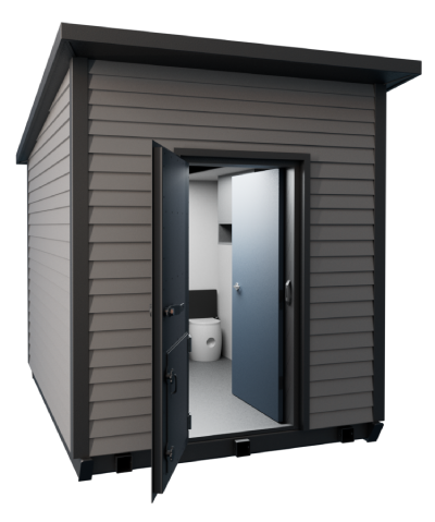
Even where fires are infrequent at a given address, the fire that does arrive can move faster than a safe departure allows, and roads can close without warning. An on-site refuge is designed for situations when evacuation becomes impossible to protect both your family and valuables, especially in the instance of a burnover.
The FORT is an above-ground refuge engineered for wildfire conditions, tested to withstand up to 2,000°F burnover, with a managed air system to keep the interior breathable while a fire front passes.
It works as one layer of a broader preparedness strategy, alongside evacuation planning and home hardening, and never as a substitute for evacuating early. It provides another layer of protection if a wildfire prevents you from evacuating safely. For a household in a Very High likelihood county, that backstop is worth understanding before a season when you might need it, not during one.
Learn About the FORT
Frequently Asked Questions
The United States averages about 63,000 wildfires a year, burning roughly 7 million acres, based on the 2016 to 2025 average from the National Interagency Fire Center. That is more than 170 fires a day, though most are small and contained quickly. Totals swing year to year: 2024 saw nearly 65,000 fires, while 2025 burned about 5.1 million acres, well below the prior year.
Wildfires occur most often in the West and in a few high-count states, led by California, Texas and North Carolina by number of fires. The states that burn the most land are different, with Oregon, Texas, California, Idaho and Alaska trading the top spots, because fire count tracks population while burned acreage tracks fuel and remote terrain. To see your own area's odds, our roundup of wildfire risk tools shows how to check local likelihood.
California usually records the most wildfires of any state, several thousand a year, and burned about 2.57 million acres across 8,835 fires in 2021. Its season runs roughly late spring through fall, and the most destructive fires tend to come in September and October when Santa Ana and Diablo winds drive fast-moving blazes. Our complete guide to fires in California covers the state's season and risk in more depth.
Wildfires are not clearly happening more often, but they are burning more land. Over the past several decades the number of fires per year has stayed fairly steady while total acreage burned has trended upward, meaning the biggest fires are getting larger even as annual fire counts hold roughly level. The National Interagency Fire Center publishes the year-by-year totals behind that trend.
An on-site wildfire refuge is worth considering wherever a fire could cut off evacuation, even in a lower-frequency area, because consequence matters as much as frequency. Evacuating early is always the safest choice. For the case where escape is not possible, an above-ground, tested refuge like the FORT provides a protected space as one layer of a plan that still prioritizes leaving early.
Key Takeaways
- The US averages about 63,000 wildfires and 7 million acres a year (2016 to 2025).
- Fire counts have held steady for decades while acreage burned has climbed: bigger fires, not simply more.
- The states with the most fires aren't the states that burn the most land.
- California leads in fire count, and its fall winds drive the most destructive blazes.
- Globally, most burned land is grassland and savanna, far from most homes.
- Frequency is local, so check your county's wildfire likelihood, not the national number.
- Let your local frequency set your prep cadence, and always plan to evacuate first.
Final Thoughts
National wildfire frequency gives context, but local wildfire likelihood is more useful for household planning. Check your own area's likelihood, then match your preparation to it rather than to the news cycle.
A realistic plan leads with early evacuation and layers protection behind it, from defensible space and a hardened home to an on-site option like the FORT for the moment leaving isn't possible. Higher wildfire frequency may require more frequent preparation, but evacuation should remain the first step when a warning is issued.